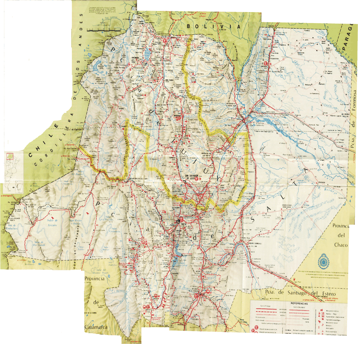
 MAPA GENERAL DEL NOA (SALTA/JUJUY)
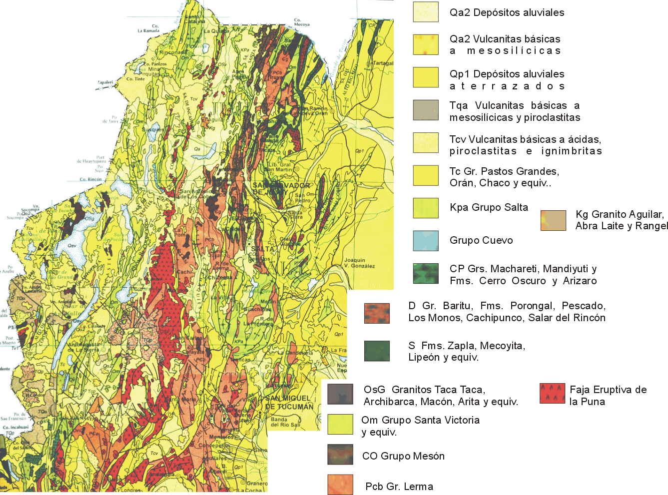
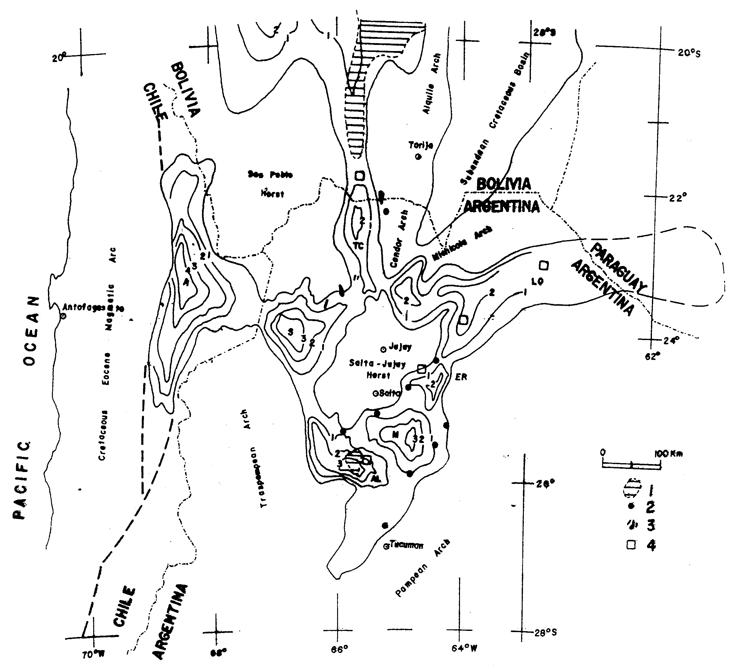
 CONFIGURACION DE LAS CUENCAS SEDIMENTARIAS CRETACICO/TERCIARIAS DEL SECTOR NORTE DE ARGENTINA, BOLIVIA, CHILE Y PERU
 AFLORAMIENTOS DE LAS UNIDADES SEDIMENTARIAS CRETACICO-TERCIARIAS DEL NOA
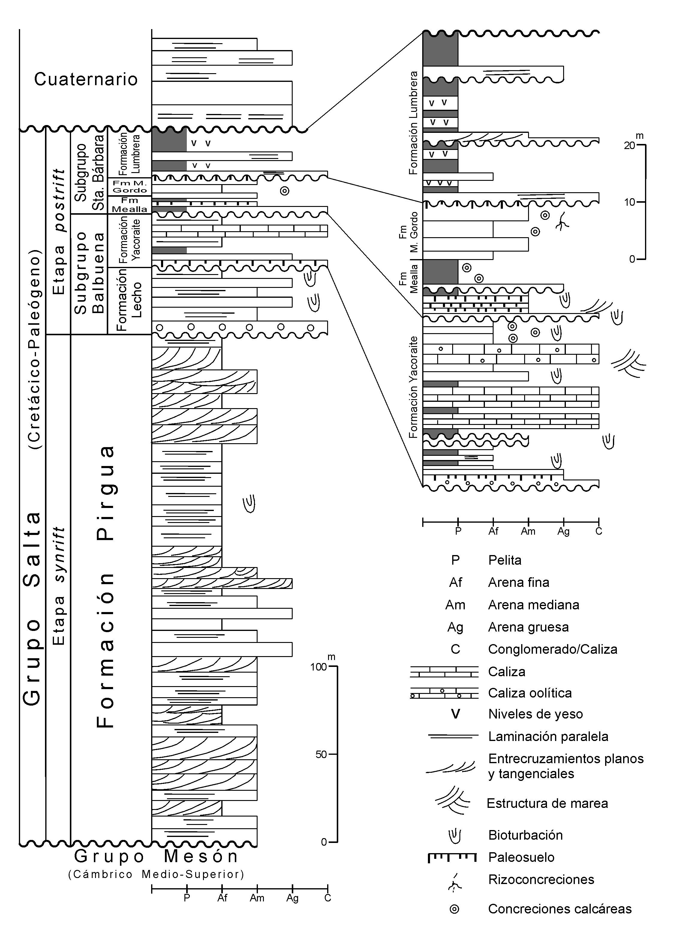
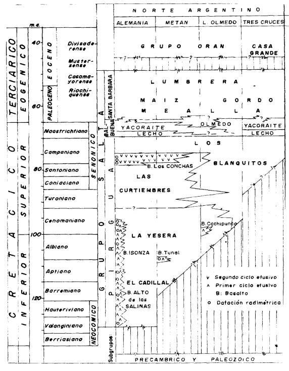 ESQUEMA ESTRATIGRAFICO DEL GRUPO SALTA
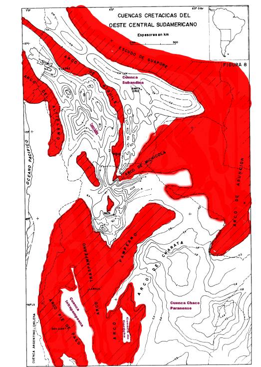
 CONFIGURACION DE LA CUENCA DEL GRUPO SALTA
CONFIGURACION DE LA CUENCA DEL GRUPO SALTA
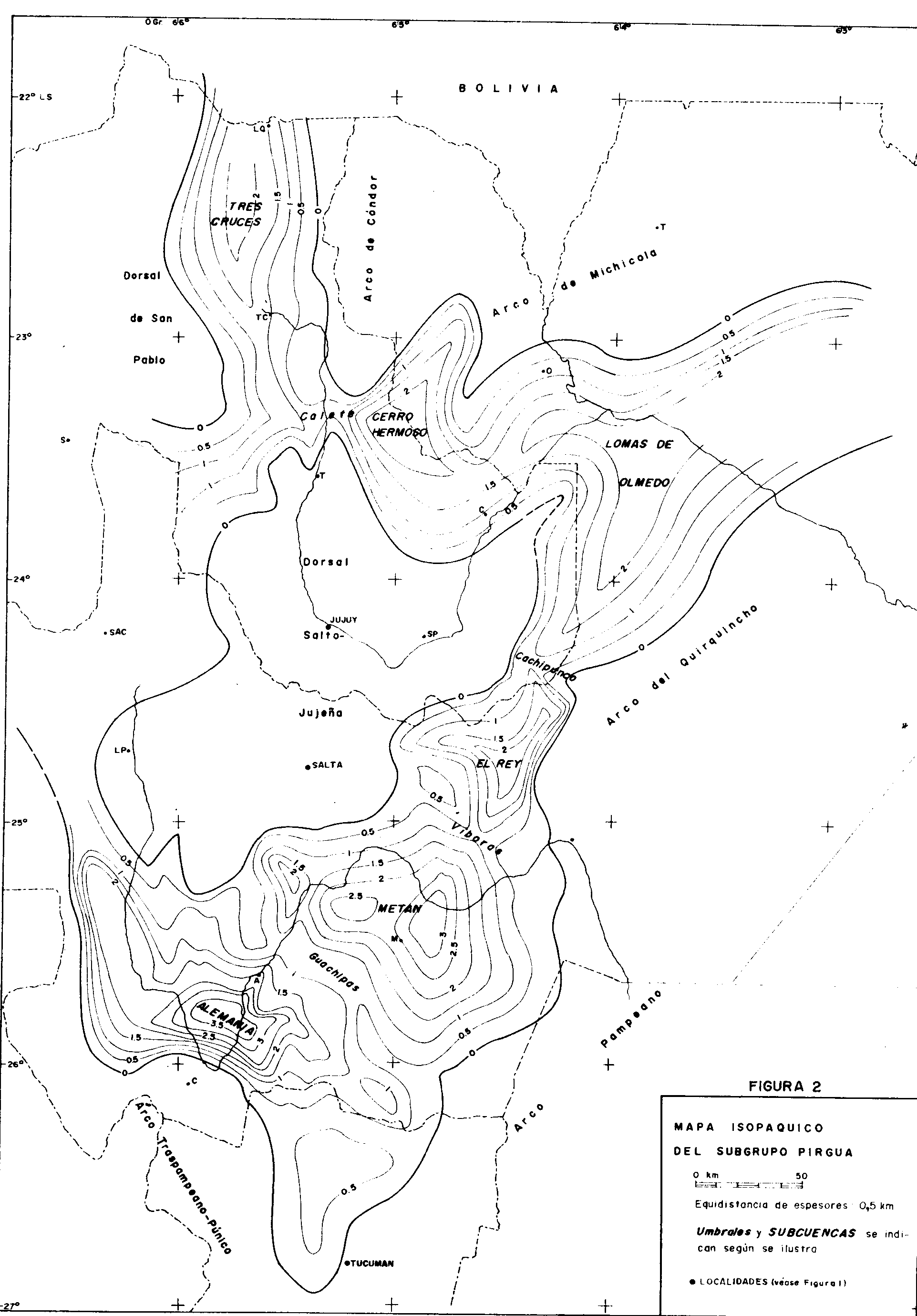
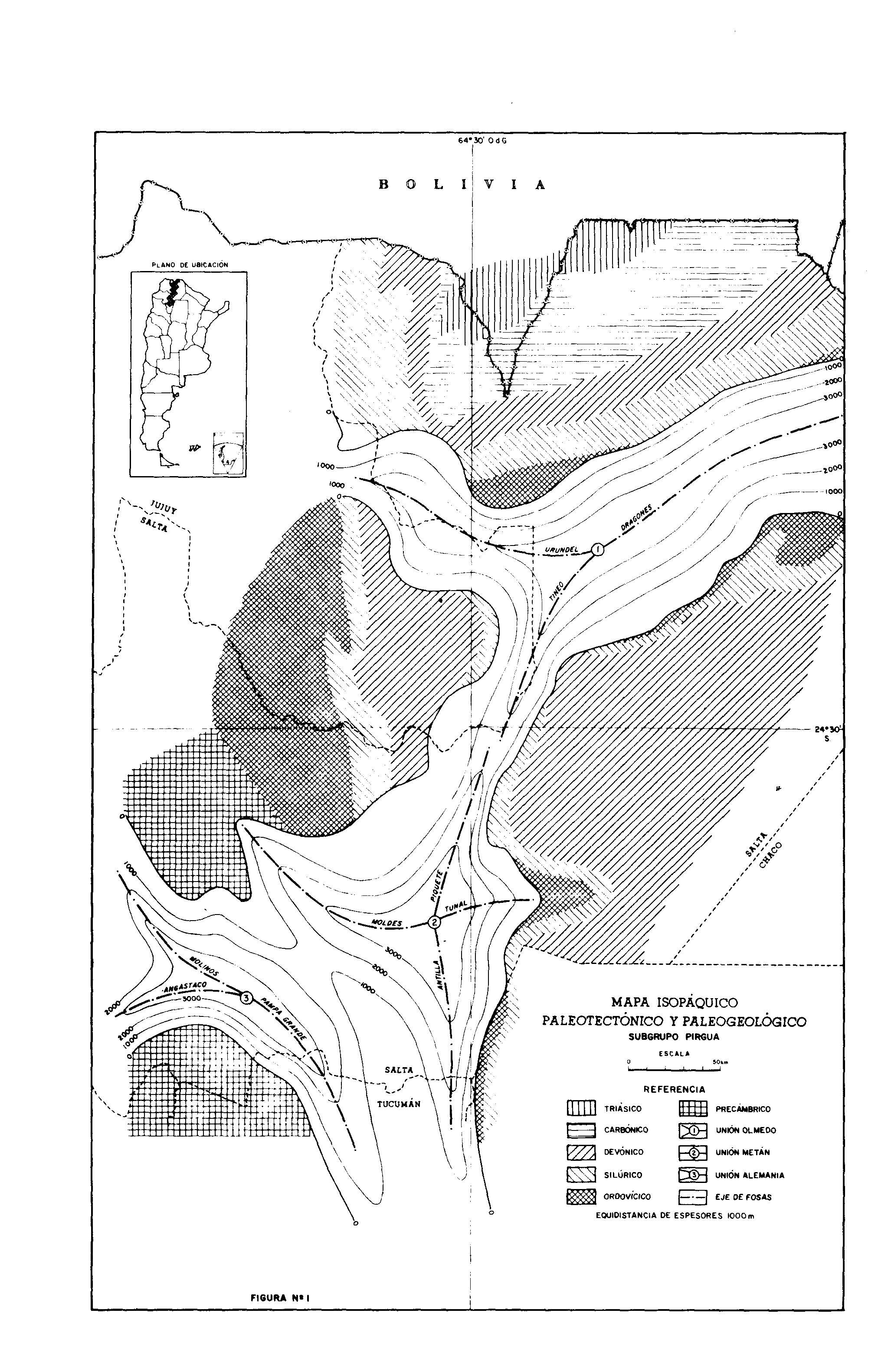
Isopáquico Subgr. Pirgua
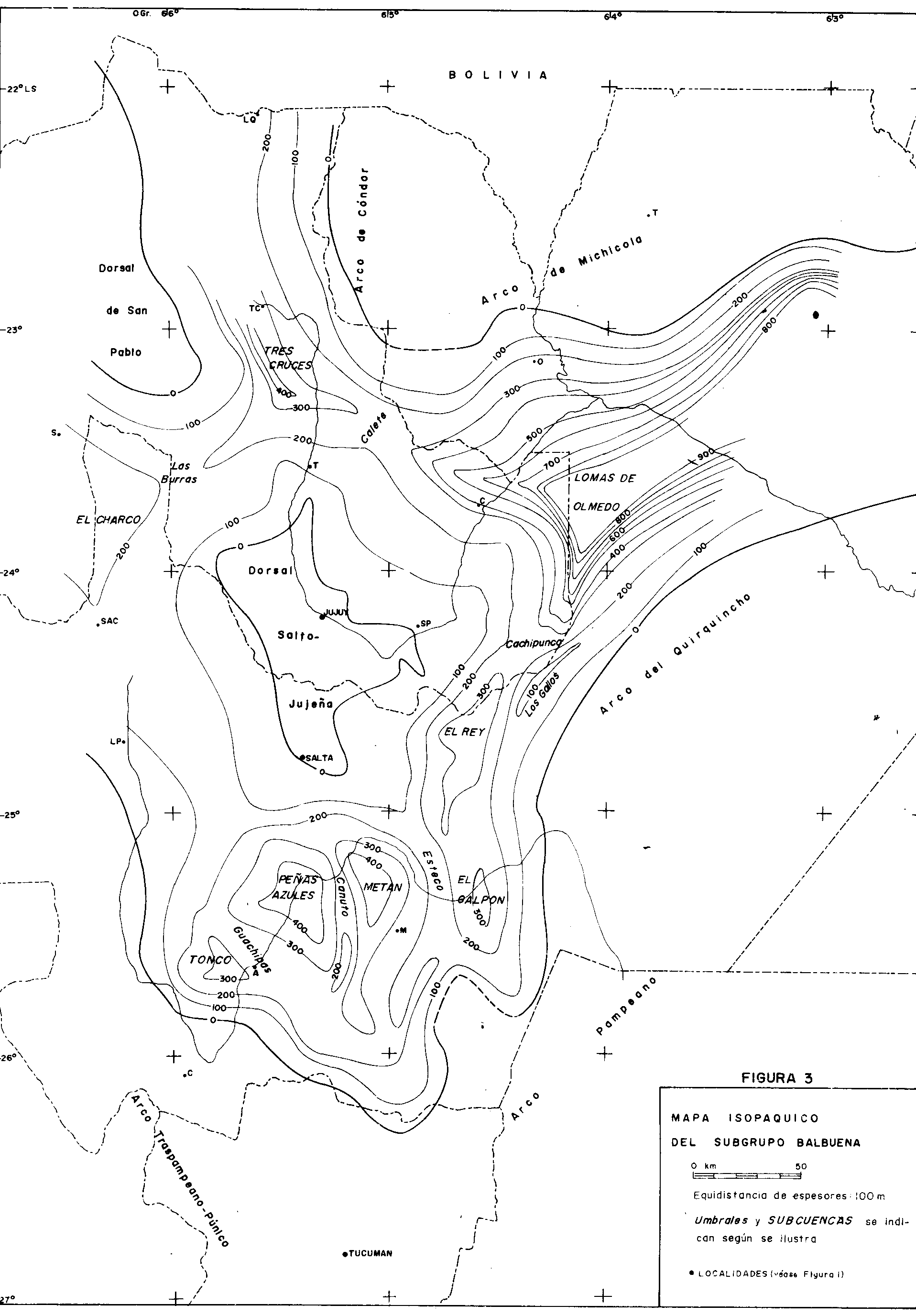
Isopáquico Subgr. Balbuena
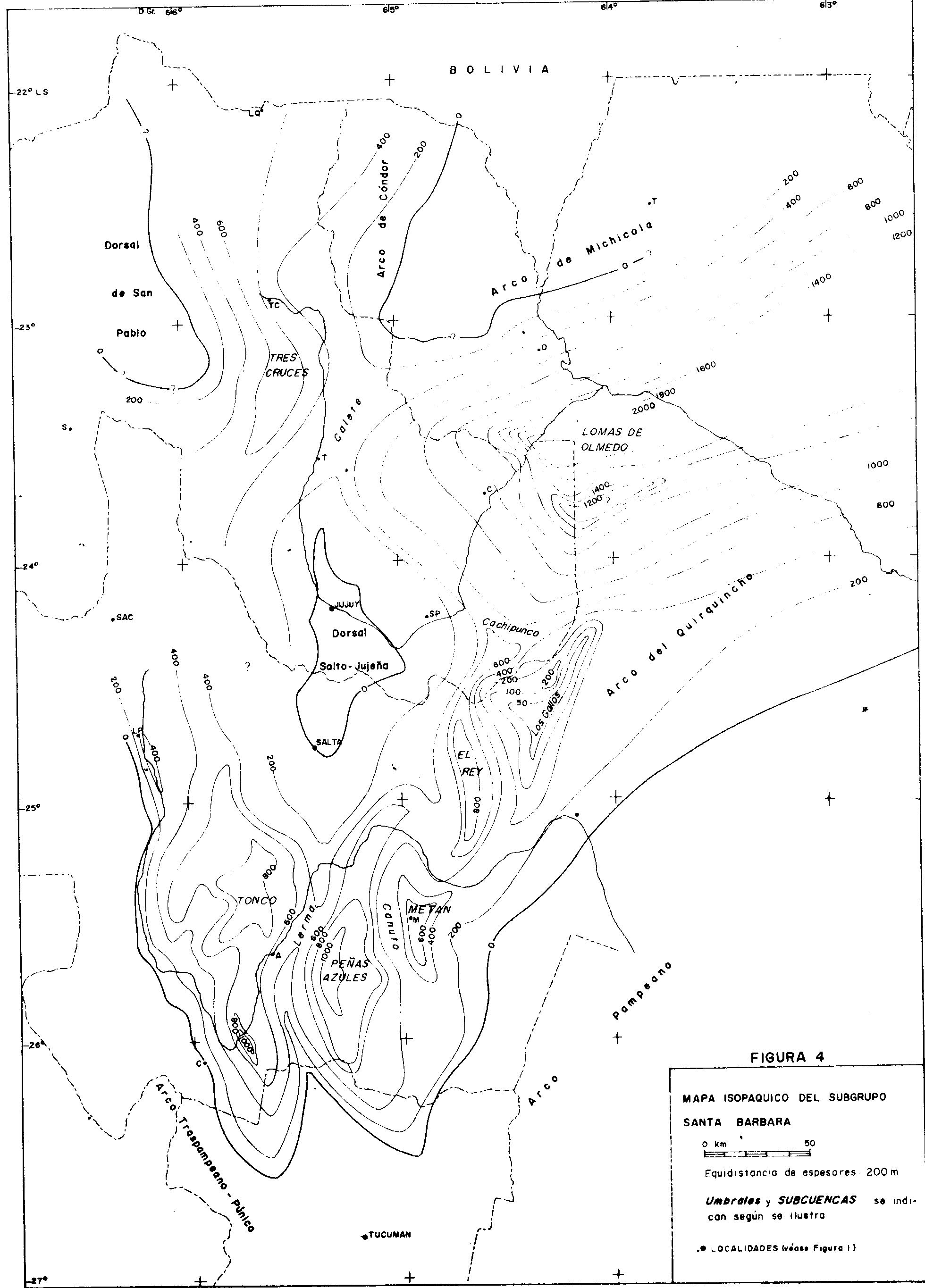
Isopáquico Subgr. Santa Bárbara
Configuración Fm Yacoraite
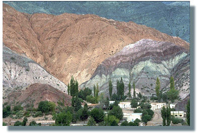
AFLORAMIENTOS DEL GRUPO SALTA EN PURMAMARCA
LAS ACUMULACIONES
SINRIFT PREMAASTRICHTIANAS
Los depósitos premaastrichtianos del Subgrupo Pirgua
representan la etapa sinrift en la evolución de la cuenca. En el depocentro de Alemanía aflora uno de
los perfiles más completos del Subgrupo.
SUBGRUPO PIRGUA
La evolución del Subgrupo Pirgua se divide en dos
episodios principales, sea en términos de unidades
tectosedimentarias (Gómez Omil et al., 1989) o en base a la
distribución regional de sus Formaciones.
El primer episodio de relleno de las fosas comenzó con el Conglomerado La Yesera, muy bien documentado en los depocentros de Alemanía y de Metán.
La Yesera Formation: description
This formation is composed of three main sections defined
in the Alemanía and Brealito subbasins (Fig. 3).
The lower La Yesera Formation is composed of conglomerates,
and the middle part of the formation is
composed of siltstones and sandstones. The lower and
middle sections are arranged in a finning-upward sequence.
The upper La Yesera Formation comprises conglomerates similar to those of the base. This upper
section represents the base of another finning-upward
sequence that continues in the Las Curtiembres Formation.
The initial faulting of the basin produced depressions
where the La Yesera Formation accumulated (Salfity
and Marquillas 1994). The subsidence was remarkable in
the Brealito subbasin, where thickness surpasses
2,400 m. This initial sedimentation accumulated conglomerates
and, in a lower proportion, sandstones and
siltstones (Fig. 3a).
In the southernmost region of the
basin, the Alto de Las Salinas Volcanic Complex lavas
were produced. The coarse-grained deposits of the lower
La Yesera Formation are up to 300 m thick in the
Alemanía subbasin and 1,000 m in the Brealito subbasin.
Close to the base, the deposits also show alternation
of dirty lithic sandstone with brown-reddish siltstone.
The middle La Yesera Formation is composed of wackes
and siltstones; maximum thickness is 350 m in the
Alemanía subbasin and 1,300 m in the Brealito subbasin.
The upper La Yesera Formation is almost entirely
composed of conglomerates. In the base of this section,
the Isonza Basalt (Fig. 2) of probably a Cenomanian age
(96±5 to 99±5 Ma, K/Ar whole rock) is interbedded
(Valencio et al. 1976).
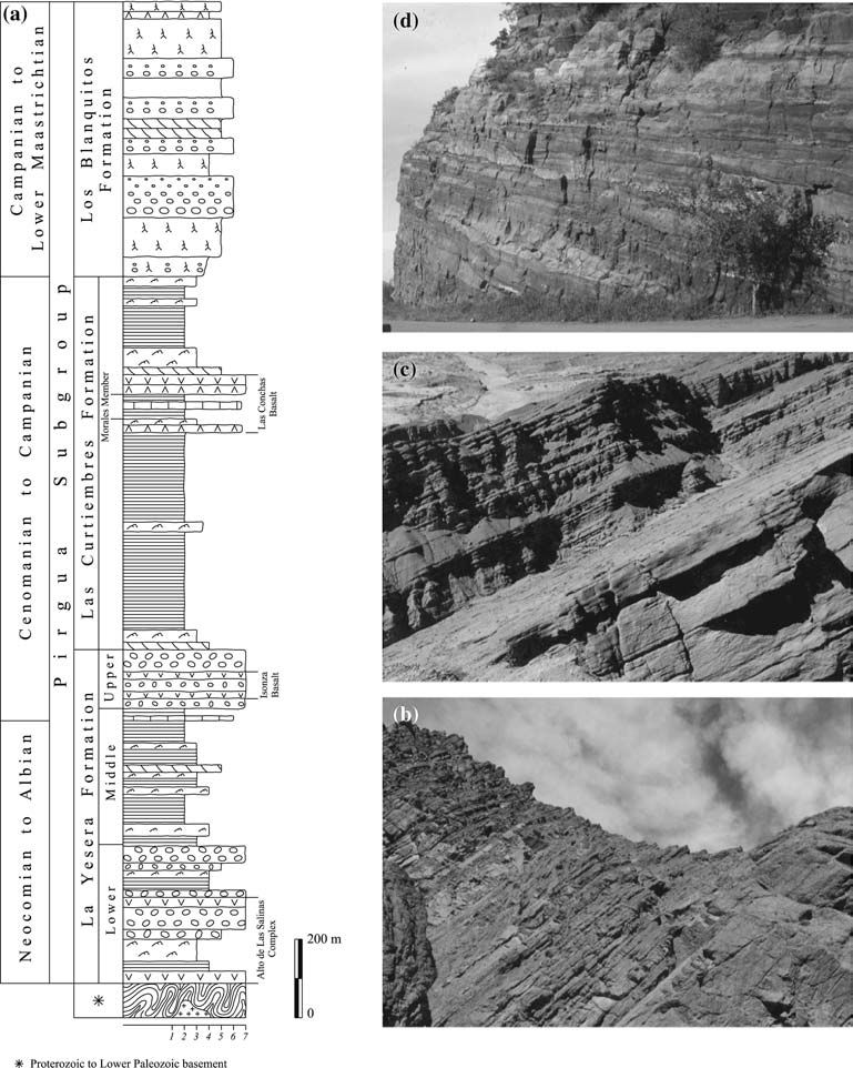
The Isonza volcanism was associated
with the rift margin faults and accumulated several
flows of a thickness of up to 40 m. Maximum
thickness in this upper section is 300 m in the Alemanía
and Brealito subbasins. The contact between the middle
and upper La Yesera Formation sections is concordant,
with the exception of areas lesser in subsidence, such as
the north of the Alemanía subbasin (near to the Salta-Jujuy high), where the contact is slightly erosive.
In the lower and upper La Yesera Formation, the
conglomerates show a dark reddish-brown color, they
have scarce interbedded wackes and siltstones. The
conglomerates are usually clast-supported without gradation,
with clasts that vary from boulders to pebbles.
The conglomerate matrix is poorly sorted, is composed
of clay and silt to coarse-grained sand and is lithic or
arkosic in petrography (Sabino et al. 1998). These conglomerates
are interpreted as debris-flow deposits. The
wackes show a brown-reddish color and frequent normal
gradation, they are rich in clay and lithic clasts,
except in the Brealito subbasin where they are arkosic.
The siltstones are dark brown-reddish in color with
slightly marked lamination; they are sometimes massive.
The characteristics of these fine-grained rocks are coincident
with mud flat deposit. The deposits of the lower
and upper La Yesera Formation are associated with
basaltic volcanism.
In the deposits of the middle La Yesera Formation,
two main facies associations are observed. The first
facies association consists of medium- to fine-grained
dirty lithic and arkosic sandstone, with cross or parallel
stratification in 0.5 m thick tabular beds and
2–4 m thick lenticular beds. They correspond to sand
bar elements of a sandy fluvial environment (Miall 1996). The other facies association is composed of rich
clay siltstones and lithic fine-grained wackes in tabular
beds of 1 to 2 m thick; this association suggests low energy
processes.
In the Brealito subbasin (Fig. 1a),
siltstones and very fine-grained sandstones, containing
some green shale and micritic limestone with chert
nodules, were accumulated; these facies have the
characteristics of a shallow subaqueous environment.
This formation is poor in fossils. Some remains of
undetermined plants and very few undetermined algae
and ostracod microfossils were found (Boso et al. 1984)
in the thin lacustrine limestone at the top of the middle
La Yesera Formation in the Brealito subbasin. Trace
fossils are frequent in the sandstone interbedded in the
middle section.
Las Curtiembres Formation: description
After the Isonza basaltic volcanic event (Fig. 2), the finegrained
sediments of the Las Curtiembres Formation
widely accumulated in the basin (with the exception of
the Tres Cruces subbasin). The areas of greater subsidence
were located near the faults where over 2,000-mthick
sediments deposited (Brealito, Alemania, Metan
and, probably, Lomas de Olmedo subbasins) (Fig. 1a).
The faults along the rift border were active during the
whole synrift stage. The faults in the inner subbasin,
which were active during the La Yesera Formation
before, became inactive or showed less movement
(Bianucci et al. 1981; Cristallini et al. 1998). Similar
evolution of the faults has been reported by Gawthorpe
and Leeder (2002) in the East African lakes.
The main facies of the Las Curtiembres Formation is
dark brown-reddish clayey siltstone, with slight lamination,
and with little moulds of halite crystals in some
cases (Brealito subbasin). There are thin layers of wacke
and lithic fine-grained, light brown-reddish sandstone,
sometimes micaceous and some greenish, and also siltstone
and claystone with frequent nodules of copper and
uranium (Sureda et al. 1984). These facies correspond to
shallow subaqueous deposits.
Near the top of this formation in the Alemanía and
Metán subbasins, Las Conchas Basalt (Reyes and Salfity
1973) was formed by Campanian pyroclastic flows and
lava flows dated 78–76 Ma (Valencio et al. 1976; Reyes
et al. 1976; Galliski and Viramonte 1988) (Fig. 3a). This
volcanism occurred in the center of each subbasin, not
along their borders as the previous volcanic events.
Green siltstone and some micritic limestone with
chert nodules accumulated in the Alemanı´a subbasin.
This 15-m-thick deposit contains pipid frogs similar to
the Eoxenopoides genus, denominated Saltenia ibanezi
Reig 1959 (Baez 1981), and plant remains probably from
Bennetitals (Archangelsky, Ibanez 1960). There are frequent
traces such as Palaeophycus and Taenidium (Luis
Buatois, personal communications) in the thin layers of
fine-grained sandstone that alternate in the pelitic succession.
El segundo episodio de relleno sinrift lo representa la
parte superior de la Formación Los Blanquitos, que niveló los
depocentros e inclusive se acumuló sobre los altos estructurales
internos de la cuenca (Calete, Cachipunco, Las Víboras
y Guachipas).
Los Blanquitos Formation: description
The Los Blanquitos Formation represents a coarsening upward
sequence. The base is usually transitional with
the siltstones of the Las Curtiembres Formation, while
in the middle and upper parts of the formation, the
coarse-grained sandstones and the conglomerates are
frequent. The Los Blanquitos Formation thickness is
usually more than 700 m (Fig. 3a), but it surpasses
1,500 m towards the central part of the Alemanıa subbasin.
The formation is intensely eroded in the Brealito
subbasin (Boso et al. 1984) as a consequence of the
inversion of the western area of the Salta basin during
the Incaica phase.
During sedimentation of the Los Blanquitos Formation,
arkosic and lithic, medium- to coarse-grained
and ill-sorted sandstones containing little clay matrix
accumulated, as well as fine-grained, pink-orange grayish
to brown-reddish conglomerates in layers up to 6 m
thick and with normal gradation. Commonly, incipient
carbonate paleosols formed with noticeable marks of
roots and abundant bioturbation.
In the Metan subbasin,
this formation is composed of thick, massive or lowangle
cross-bedded strata of medium- to fine-grained
arkosic sandstones (Fig. 3d). In the profiles of this
subbasin, the interbedding of bioturbed siltstone is more
frequent. In the Alemanıa and Metan subbasins, the
sandstones of the Los Blanquitos Formation contain
quartz and feldspars of the granitoids that crop out in
the west part of the Brealito subbasin (Sabino 2002).
At the top of Los Blanquitos Formation in the
southern area of the Alemanıa subbasin, remains of
Sauropod dinosaurs Titanosauridae and two teeth of
Carnosauria, probably Coelosauria, were found (Bonaparte
and Bossi 1967). Later, due to new findings, the
remains of titanosaur were assigned to the Laplatasaurus
genus. Some bones of another Sauropod of an indefinite
family and post-skull remains of a new species of therapod
were also found: Unquillosaurus ceibalii sp. nov.
(Powell 1979; Bonaparte and Powell 1980).
All their
remains were assigned to the Senonian (Powell 1979),
thus confirming the age of Los Blanquitos Formation.
The Palmar Largo volcanic rocks (Ma¨ del 1984) lie between
the top of Los Blanquitos Formation and the base
of the Balbuena Subgroup in the Lomas de Olmedo
subbasin. They are dated as having 70±5 Ma in age
(K/Ar) (Gomez Omil et al. 1989), which means that the
upper part of the Los Blanquitos Formation must have
accumulated in Early Maastrichtian.
LAS ACUMULACIONES POSTRIFT MAASTRICHTIANO-EOCENAS
La ingresión maastrichtiano-paleocena en el norte de la Argentina estuvo vinculada con los cambios globales contemporáneos con el diastrofismo Ranquel. Los dos pulsos de la fase Ranquel señalan, respectivamente, el inicio y la culminación de la inundación epeirogénica del Subgrupo Balbuena, ocurrida en un marco de tranquilidad tectónica.
SUBGRUPO BALBUENA
The Balbuena Subgroup was accumulated during
the Maastrichtian to Early Paleocene (Fig. 2); it
represents the early postrift stage. The typical section is
400–500 m thick. The lower part is formed of white
sandstones (Lecho Formation), and the upper part
contains gray limestones (Yacoraite Formation) and
dark pelites (Olmedo/Tunal Formations). These deposits cover the Pirgua Subgroup and underlie the Santa Barbara Subgroup.
Lecho Formation: description
The basal deposit of the Balbuena Subgroup is represented
by white sandstone of the Lecho Formation; its
average thickness is 150 m (Salfity 1980) (Fig. 5a, b).
The main facies is of fine- to medium-grained calcareous
sandstones thickly stratified to massive, which were
accumulated by medium- to high-energy tractive currents.
Also, clean sandstone containing rounded quartz
and high-angle cross strata, and coarse-grained bioturbated
calcareous sandstone (quartzose to arkosic) were
deposited. These facies are the consequence of wind
action and the reworking of the sediments by water
currents.
In the Meta´n subbasin (Fig. 1a), the sandy to silty
facies contain a Senonian association of tetrapods and
birds. The bones of the Sauropods (Saltasaurus loricatus),
Coelurosauria (Noasaurus leali) and Carnosauria and
from three undetermined orders of continental birds were
preserved (Bonaparte and Powell 1980).
Limestone, shale and claystone are present in some
sections of the basin, in the lower third of the formation.
This could be related to an early flooding event in the
basin. In some sections of the Tres Cruces subbasin, this
flooding event is represented by limestone, shale and
claystone facies. The calcareous microfacies demonstrate
the occurrence of low-energy stages (micrite with ostracods
and bivalves) alternating with high-energy stages
in which grainstone and packstone with oolites, intraclasts
and pellets predominated (Marquillas and Salfity
1990).
In other profile sections of the north and northwest parts of the Meta´n subbasin, the base of the formation consists of a decimeter- to meter-scaled assemblage of green, gray and black shales, mudstones and fine-grained sandstones. The pelitic rocks of a reducing environment, although many of them were oxidized later, generally have copper and uranium mineralization; besides, they show a rich content of palynomorphs, which are currently being studied.
The Lecho Formation also shows red facies (sandstone
and shale) along the eastern border of the Metan subbasin
and red to purple facies in the Alemanıa subbasin. Here,
the Lecho Formation (or Quitilipi Formation) consists of
mega cross-stratified or massive sandstones, black, green
and yellowish-gray shales with subaqueous structures and
mud cracks and some levels of limestone and calcareous
nodules. The pelitic deposits are laminated and some
sandstones are finely stratified. No fossils were found.
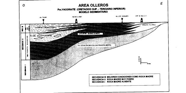
Yacoraite Formation: description
The Yacoraite Formation, 200 m maximum thickness
(Fig. 5a, c), is an excellent marker horizon in the Salta Group, due to its calcareous–dolomitic composition. Its
intense yellow of weathering color dominates the gray
color of the fresh rocks. Its outstanding topographic
relief is most characteristic.
The lowest part of the formation consists mainly of
high-energy limestones and calcareous sandstones in
well-defined strata of 0.3 m average thickness. They are
medium- to coarse-grained oolitic grainstone with
spherical sparitic oolites, oolitic packstone, intraclast
limestone and light grey calcareous sandstone. White or
white-yellowish tuff layers are common. Fossils are
scarce, restricted to gastropods, pelecypods and a few
miliolid foraminifers, all of them characteristic of restricted
marine conditions. The cathodo-luminescence
studies of the limestones (Marquillas and Matheos 2000) permitted the detailed definition of the marine cementation
events in the early diagenetic processes (high
luminescence, high content of Mg and very rich in Mn).
Limestone and fine-grained sandstone, with wave and
current ripple lamination sometimes associated with
hummocky cross-stratification, are common in the lower
and middle part of the formation. In the middle, stratification
is thinner, ranging from 10 to 15 cm, which
gives a flaggy appearance to the limestones. The predominant
facies of the middle part indicate moderate
energy. They are represented by fine-grained oolitic
grainstone, packstone and wackestone that contain only
gastropods. Stromatolitic boundstone is rare, and there
are some sandstones. Low-energy facies such as micrite
and shale are scarce. Generally, they contain ostracod
valves, and fragments of undetermined fish.

Especially in the Meta´n and Alemanı´a subbasins
(Fig. 5c), the upper part of the formation is characterized
by a recurrent succession of shallowing events. They
are represented by fine-grained rocks (black, green and
gray shale, calcareous mudstone and dolomicrite), which
alternate with oolitic and intraclastic grainstone, and
stromatolitic boundstone. The stromatolites are domal
and are up to 90 cm high. There are some layers of
gypsum and anhydrite.
Shales usually contain small phosphatized remains of
fish. Fish species in the Yacoraite Formation are the
Pucapristis branisi, compared with the modern pristidae,
which are related to coastal marine environments
(Powell 1979) and the Coelodus toncoensis, which would
indicate a similar environment (Benedetto and Sanchez
1972; Cione 1977). Besides, hypocoracoids of Gasteroclupea
branisai (Acen˜ olaza 1968; Reyes 1972) and different
siluriforms were found. Even though the
siluriforms constitute a very important group of freshwater
fish, the Cretaceous and a large number of
Paleocene forms were of marine or mixed environments
(Cione and Laffite 1980; Cione et al. 1985).
This formation also contains ostracods, foraminifers,
pelecypods, gastropods, algae and palynomorphs. The
most common ostracod is the Ilyocypris sp. Some of the
most frequently mentioned foraminifers are the rotaliids,
such as Ligulogavelinella frankei, Orostella turonica and
Bilingulogavelinella sp. and forms similar to Discorbis
aff. cretacea, Valvulineria infrecuens, V. marianosi and
V. allomorphinoides and Miliolinella sp., among the
miliolids (Me´ndez and Viviers 1973; Kielbowicz de Stach
and Angelozzi 1984). Palynological studies of limestone
and shale from Lomas de Olmedo subbasin cores
revealed forms resembling Aquilapollenites magnus,
Crassitriapertites brasiliensis, Zlivisporis blanensis,
Gabonisporis vigourouxii, Psilastephanosporites cf.
brasiliensis, numerous polyplicated grains and, in lower
numbers, Tricolpites sp., Ulmoideipites sp., aplanospores
algae and deflandroid cysts, indicators of brackish
conditions (Moroni 1982). Papu and Melendi (1984)
mentioned mixed conditions of fresh and brackish water,
after the finding of massulae of Azolla cretacea and
dinoflagellates. The variable salinity of the water is also recorded by the presence of different charophytes,
especially characeae and porocharoideae (Musacchio
1972; Kielbowicz de Stach and Angelozzi 1984) of
freshwater. The fossiliferous content is similar to that
recorded in deposits of the same age in Bolivia (Gayet
et al. 1993).
The deposits of the formation present very well
preserved dinosaur footprints (Alonso 1980; Alonso and
Marquillas 1986) in outcrops of the Alemanı´a subbasin
in the west. There are various morphotypes recorded in
calcareous fine- to very fine-grained sandstone of a grayyellowish
color, with ripples and desiccation cracks,
alternating with green shale. They are ichnites of a
Carnosauria (Salfitichnus mentoor) and of two ornithopods,
probably hadrosaurids (Taponichnus donottoi,
Telosichnus saltensis).
The association is complete with numerous oriented but badly preserved footprints of tetrapods, probably herbivore dinosaurs. Stratigraphically, on top of them, tridactylus ichnites of birds (Yacoraitichnus avis) are recorded. Other sections in the same area have numerous well-preserved footprints of Ornitischia (Hadrosaurichnus australis) in limestone in the lower part of the formation. Also, dinosaur footprints are observed in the stromatolitic plain of the Alemanı´a subbasin and coastal deposits of the Meta´n subbasin. The habitat was also favourable for crocodiles such as Dolichochampsa minina (Gasparini and Bu¨ ffetaut 1980).
Tunal and Olmedo Formations: description
The Olmedo Formation (Fig. 2) is a deposit essentially
controlled by decantation and evaporation processes.
This formation is composed of black and gray shales,
siltstone with salt and gypsum crystals and micritic and
dolomicritic limestone. There are also thick accumulations
of halite with anhydrite and gypsum.
Evaporites
overlying the Yacoraite Formation are known as the‘‘Salino Member’’ in the eastern part of the basin
(Lomas de Olmedo subbasin, Fig. 1a). The thickness of
the Olmedo Formation outcrops averages up to 60 m,
but on the subsurface of the Lomas de Olmedo subbasin
(Fig. 1a), thickness varies from 150 to 200 m (Moreno
1970; Carle´ et al. 1989). However, it surpasses 900 m
(Moreno 1970) because of a thickening of the Salino
Member due to tectonic controls (Gomez Omil et al.
1989; Carle´ et al. 1989), or perhaps due to diapiric
structures. The shales contain pollen.
In a wide region of the Meta´n and Alemanı´a subbasins
(Fig. 1a), there are deposits equivalent to the Olmedo
Formation, called Tunal Formation (Turner et al.
1979), of 40 m average thickness (Fig. 5a, d). It is made
up of gray, green, black and brown-reddish shales and
mudstones, gypsiferous fine-grained sandstone and
abundant small layers of gypsum, and scarce ochrecolored
dolomicrite. Nevertheless, in other sections,
the facies of the Tunal Formation have scarce or no
sulfates (Novara 2003).
It possesses a rich content of palynomorphs (Quattrocchio et al. 1988, 2000) in which
angiosperms dominate, e.g., Ephedripites sp., Gemmatricolpites
subsphaericus, Rhoipites sp., Retitricolporites
sp., Pandaniidites texus, Myriophyllumpollenites sp. and
Verrustephanoporites cf. Simplex; and Podocarpidites
marwickii among the gymnosperms. Besides, it contains
algae (Pediastrum sp.), fungi (Dicellaesporites sp.,
Multicellaesporites sp.) and other palynomorphs
(Mtchedlishvilia saltenia, incertae sedis).
SUBGRUPO SANTA BARBARA
Since the Middle Paleocene (Fig. 2), the subbasins
(Fig. 1a) remained active with a very low subsidence
rate, which caused the accumulation of three units of regional continuity, the Mealla, Maı´z Gordo and
Lumbrera Formations (Moreno 1970) (Fig. 6a). The
succession is dominated by red fine-grained sandstone
and siltstone and green mudstone. This deposit represents
the late postrift stage of the Salta basin.
Mealla Formation: description
The Mealla Formation is the lowermost unit of the
Santa Ba´ rbara Subgroup (Fig. 6a). It is characterized
by clastic deposits with thickness ranging from 100 to
150 m (del Papa and Salfity 1999). In the Meta´n and
Alemanı´a subbasins, it consists of fine- to mediumgrained
sandstone levels with erosive bases, finningupward
tendency, lateral accretion structures (LA
macroform of Miall 1985) and current ripples.
Finegrained
sediments interbedded with the sandstone succession
are integrated by massive, red siltstone, calcareous
nodules and very thin beds of fine-grained sand
with planar lamination and current ripples (Fig. 6b).
Frequent remains of freshwater turtles (Pelomedusidae)
and mammals (Notoungulata, Simpsonotus praecursor
sp. nov.) were found in this environment (Pascual et al.
1981). The notoungulates, which had a herbivorous
diet, consisting especially of leaves, are significant for
paleoenvironmental reconstruction (Pascual et al.
1978).
Toward the east, in the El Rey and Lomas de Olmedo
subbasins (Fig. 1a) red massive siltstone, discrete domal
stromatolites, and heterolithic facies of green claystone
and white sandstone with wavy bedding and wavereworking
structures accumulated. This facies association
contains palynomorphs, such as Pandanaceae and
Palmae (Nypa), Myriophyllumpollenites sp. and Azolla
sp., Ulmaceae and Aquifoliaceae and Ephedraceae
(Quattrocchio et al. 1997; Quattrocchio and Volkheimer
2000a). In the Lomas de Olmedo subbasin, the main
facies association is composed of gypsum layers interbedded
with red siltstone and very fine-grained sandstones
(Go´ mez Omil et al. 1989).
Maı´z Gordo Formation: description
The Maı´z Gordo Formation overlays the Mealla Formation,
the main thickness ranging from 200 to 250 m.
It is characterized by a succession of coarse- to finegrained
sandstone in the west of the Alemanı´a subbasin.
Beds have erosive bases with coarse-grained sands and
pebbles as lag deposits. Trough and tabular cross-bedding,
also unidirectional ripples, are the common sedimentary
structures. Fine-grained rocks are absent or less
thick and are characterized by heterolithic facies and
calcareous nodules; in some places, root traces were
observed.
According to the main facies association, in the
eastern part of the Alemanı´a subbasin and in the El Rey
and Lomas de Olmedo subbasins (Fig. 1a), the Maı´z Gordo Formation can be divided into three distinctive
sections.
The lower section begins with a thick succession of
red massive siltstone with intercalation of centimeterthick
fine-grained sandstone displaying parallel lamination
(Fig. 6a). Mud cracks, brecciated surfaces and
bioturbation are common sedimentary structures.
The middle section is characterized by the occurrence
of limestone (Fig. 6c). In the El Rey and Lomas de
Olmedo subbasins (Fig. 1a), carbonate facies dominate.
The vertical facies assemblage consists, from base to top,
of green laminated mudstone and marls, wackestone,
packstone and oolitic grainstone, displaying wavy
and lenticular bedding and wave-reworked features Continuous beds of domal stromatolites mark the top.
The green fine-grained portion of the succession is
rich in insects like Dermaptera, Orthoptera, Hemiptera,
Coleoptera (Cockerell 1925, 1926), Odonata, Palaeomacromiidae
fam. nov. (Petrulevicius et al. 1999), fish
like Callichthyidae Corydoras revelatus and Poeciliidae
Cyprinodon primulus? (Cockerell 1925, 1926; Bardack
1961; Cione 1978) and palynomorphs. The palynomorph
communities are very similar to those in the
Mealla Formation. These communities are composed of
Pandanaceae and Palmae (Spinizonocolpites sp.) and
nonmarine dinoflagellate cysts, also, Azolla sp. and
Haloragaceae (Myriophyllumpollenites sp.) (Quattrocchio
and del Papa 2000).
This section roughly corresponds to the Thanetian ‘‘Cricotriporites guianesis’’
climatic zone of Quattrocchio and Volkheimer
(2000b). In the Alemanı´a subbasin (Fig. 1a), the facies
association consists of fine- to medium-grained sandstones,
massive to laminated green siltstones and discrete
laminar to low-relief domal stromatolites. Wavy
and lenticular bedding, current and wave ripple lamination
with less frequent mud cracks are observed.
In the upper section of the Maı´z Gordo Formation,
the facies association is composed of green shale, massive
mudstone and wave-rippled grainstone with erosive
bases and rib up mud clasts. In this level, Pediastrum
algae were recognized (Quattrocchio and del Papa 2000).
Lumbrera Formation: description
The uppermost unit of the Santa Ba´ rbara Subgroup is
the Lumbrera Formation (400–500 m thick), which
unconformably overlays the Maı´z Gordo Formation
(Fig. 2). Go´ mez Omil et al. (1989) recognized three
sections according to its lithological characteristics
.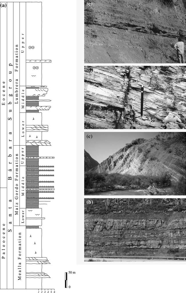
The lower section is composed of red sandstone and
mudstone. It is dominated by medium- to fine-grained
sandstone with lateral accretion geometry, with tabular
cross-lamination and current ripples. Decimeter-to-meter
thick red siltstone and fine-grained sandstone layers
with parallel lamination and current ripples are interbedded,
as well as massive red mudstone with calcareous
nodules.
The top of this section contains marsupials,
ungulates and notoungulates (Pampahippus arenalesi,
Bond and Lo´ pez 1993), Crocodylia—Sebecidae
(Gasparini 1984) and Squamata—Teiidae (Lumbrerasaurus
scagliai sp. nov.) (Donadio 1985).
The middle section of the Lumbrera Formation is
known as Faja Verde because of a continuous level of
green rocks. The facies association consists of dark green
to gray laminated claystone and sheet-like, fine sandstone
and stromatolite. Sandstone layers display wavy,
flaser-bedding and wave ripple structures.
Dark gray
shale constitutes a decimeter thick, homogeneous succession
containing between 1 and 9% of organic matter,
punctuated by very thin beds of coarse-grained siltstone
(Fig. 6d). Diverse palynomorphs: Notopollenites sp.,
Liquidambarpollenites cf. Brandonensis orest, Pediastrum
and Botryococcus algae (Quattrocchio 1978; del
Papa et al. 2002) and the fish Lepidosiren paradoxa
(Ferna´ ndez et al. 1973) were identified in this succession.
The upper section of the Lumbrera Formation
(Fig. 6a) is 300 m thick but, in some places, it is less
thick due to the erosive unconformity that limits the top.
It is composed of red massive siltstone and mudstone.
Minor fine-grained sandstone beds with parallel lamination
and wave-ripple structures (Fig. 6e), sporadic
gypsum/anhydrite nodules forming continuous levels,
mud cracks and vertical burrowing characterize this
section. Mammal remains of Eomophippus sp. were
found in this level (Mule´ and Powell 1998).
Conclusions
For almost 100 million years (Neocomian to Eocene),
different sedimentary environments succeeded each
other in the northwestern region of Argentina occupied
by the Salta Group basin, as summarized in Fig. 7.
The
environmental changes that took place through five
recognized evolutionary stages (three synrift stages and
two postrift stages) are exemplified in four subbasins.
The distribution of the sedimentary environments
demonstrates how the tectonic regimes conditioned the
geomorphology and the fill of the synrift stage.
The
synrift stage comprises three sedimentary cycles. Two of
them are successive finning-upward cycles that correspond
to the early synrift stage; they represent two cycles
with increasing subsidence rate. The third cycle is a
coarsening-upward sequence; it represents the late synrift
and corresponds to the decreasing subsidence rate of
the basin. The beginning of the first and the second
synrift cycle each correlates with the initial Mirano and
final Mirano phases (Fig. 2). Effusion of lava accompanies
the beginning of both cycles (Alto de las Salinas
and Isonza volcanic events). During the second synrift
cycle, the climax of the rift accompanied by the
volcanism in the center of the basin occurred (Las
Conchas event). In the Salta basin, the start of the late
108 synrift stage may correspond to the Peruana diastrophic
phase (Fig. 2). The end of the late synrift stage and the
beginning of the postrift stage are marked by thermal
subsidence of the basin.
Debris-flow dominated alluvial fans and scarce
basaltic flows characterize the start of the synrift fill
cycles (lower and upper sections of the La Yesera Formation;
Fig. 3a). The increasing subsidence rate during
the accumulation of the middle section of the La Yesera
Formation and during the Las Curtiembres Formation
(Fig. 3a) (synrift climax) led to the establishment of
permanent lakes, which must have increased the
humidity in the region. The final decrease in the synrift
stage subsidence rate allowed communication of the
subbasins; as a consequence, sandy rivers dominate the
depositional setting (Los Blanquitos Formation;
In the Tres Cruces subbasin, no lakes formed
due to the lower subsidence rate as compared to the
other subbasins. Common eolian deposits confirm drier
local conditions. In this subbasin, the ‘‘Pirgua Formation’’
sandstones represent the three lithostratigraphical
units that were identified in the southern region.
The postrift fill occurred in a framework of a relative
tectonic quiescence. The beginning of the postrift stage (Maastrichtian to Danian) was marked by low topography
and warm climate dominated by shallow marine
carbonate sedimentation (Yacoraite Formation;
Fig. 5a), characterized by the production of abundant
oolite, and the development of the stromatolitic plains.
The scarce variety of species and the small size of the
organisms are explained by the general stress conditions
to which they were subjected due to the variations of the
environmental parameters. The dinosaur record is
coincident with littoral positions with a marked continental
influence. The deposition of limestones was preceded
by the accumulation of fluvial-eolian white sands
of the Lecho Formation (Fig. 5a); both facies are
sometimes interbedded.
A drier climate in the Danian
led to a general regression. Saline to hypersaline lacustrine
systems and extensive mud plains developed
(Salino Member, Olmedo Formation; Fig. 2). Brackish,
freshwater and swampy lakes also evolved (Tunal
Formation; Fig. 5a).
In the late postrift stage (Danian to Late? Eocene), the
distribution of the sedimentary environments suggests
plains surrounded by low mountains and forest areas. The
fluvial dynamics of each style is in close relationship to the
flood plain preservation potential and the remains of the (Maastrichtian to Danian) was marked by low topography
and warm climate dominated by shallow marine
carbonate sedimentation (Yacoraite Formation;
Fig. 5a), characterized by the production of abundant
oolite, and the development of the stromatolitic plains.
The scarce variety of species and the small size of the
organisms are explained by the general stress conditions
to which they were subjected due to the variations of the
environmental parameters. The dinosaur record is
coincident with littoral positions with a marked continental
influence. The deposition of limestones was preceded
by the accumulation of fluvial-eolian white sands
of the Lecho Formation (Fig. 5a); both facies are
sometimes interbedded. A drier climate in the Danian
led to a general regression. Saline to hypersaline lacustrine
systems and extensive mud plains developed
(Salino Member, Olmedo Formation; Fig. 2). Brackish,
freshwater and swampy lakes also evolved (Tunal
Formation; Fig. 5a).
In the late postrift stage (Danian to Late? Eocene), the
distribution of the sedimentary environments suggests
plains surrounded by low mountains and forest areas. The
fluvial dynamics of each style is in close relationship to the
flood plain preservation potential and the remains of the organisms that lived on it. In braided rivers, high channel
mobility provoked continuous cannibalization of the
overbank deposits. It resulted in a low record of the endemic
fauna (Maı´z Gordo Formation).
Likewise, in high
sinuosity systems, permanent and slowly migrating
channels favoured the preservation of fine-grained flood
plains. These settings are rich in fossil remains that record
the contemporaneous fauna, like turtles and crocodiles
(Mealla and Lumbrera Formations; Fig. 6a). This situation
is exemplary in the different fluvial systems that were
formed in the late postrift stage. The fluvial depositional
systems associated with fossil records indicate that the
geography was dominated by sand plains and mud flats
with extensive pastures, temporally flooded in warm climate
but with marked, alternating dry and rainy seasons.
The herbivorous and leafy diets of the vertebrates together
with the presence of pollen and paleosols confirm
these conditions.
A succession of lakes was formed in the
basin center that evolved from shallow saline (Mealla
Formation; Fig. 6a), shallow brackish-alkaline (Maı´z
Gordo Formation; Fig. 6a), perennial freshwater (Faja
Verde, middle part of the Lumbrera Formation; Fig. 6d)
and clastic-saline lakes (Upper Lumbrera Formation;
Fig. 6a). The development of one lake or the other was
regulated by the alternating humid and drier climate
periods. The highest humidity conditions are recorded in
the Faja Verde of the Lumbrera Formation because the
deepest, freshwater perennial lake formed there. The
sudden desiccation of this lake, evidenced by brecciated
surfaces and mud cracks, records the beginning of a dry
period in the Upper Eocene that continued up to the
Oligocene.
Los mapas y esquemas utilizados en esta página han sido tomados/adaptados de la bibliografía correspondiente, entre la cual se incluyen los siguientes trabajos, que se recomiendan para la lectura:
Mingramm A., A. Russo, A. Pozzo y L. Cazau, 1979. Sierras Subandinas. Segundo Simposio de Geología Regional Argentina. Academia Nacional de Ciencias. Córdoba, I: 95-137.
Mon R., 1979. Esquema Tectónico de los Andes del Norte Argentino. A.G.A., revista XXXIV (1): 53-60.
Salfity J.A., R. Omarini, B. Baldis y W.J. Gutierrez, 1975. Consideraciones sobre la evolución geológica del Precámbrico y Paleozoico del Norte Argentino. Actas Segundo Congreso Iberoamericano de Geología Económica. IV: 341-361.
Turner J.C.M. y V. Méndez, 1979. Puna. Segundo Simposio de Geología Regional Argentina. Academia Nacional de Ciencias. Córdoba, I: 13-56
Turner J.C.M. y R. Mon, 1979. Cordillera Oriental. Segundo Simposio de Geología Regional Argentina. Academia Nacional de Ciencias. Córdoba, I: 57-94.